

15-16 November 2003
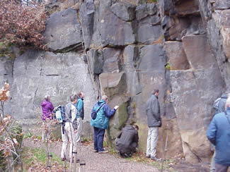 This year’s field trip was to the village of Broadbottom, to examine
outcrops and field relations of the Rough Rock, a major coarse-grained sandstone
that marks the top of the Namurian strata in the UK. Immediately above this
unit are the Coal Measures. The group were able to discuss the sedimentology,
the source rocks, the lateral persistence and the thickness of this remarkable
sheet sandstone. We examined a locality where the rock was displaced by
about 300 metres by a major fault. Later, this fault provided a zone of
weakness that was exploited by waters released from an ice-dammed lake upstream.
These waters cut down through the strata very quickly and this led to further
discussion of processes relevant to catastrophic erosion.
This year’s field trip was to the village of Broadbottom, to examine
outcrops and field relations of the Rough Rock, a major coarse-grained sandstone
that marks the top of the Namurian strata in the UK. Immediately above this
unit are the Coal Measures. The group were able to discuss the sedimentology,
the source rocks, the lateral persistence and the thickness of this remarkable
sheet sandstone. We examined a locality where the rock was displaced by
about 300 metres by a major fault. Later, this fault provided a zone of
weakness that was exploited by waters released from an ice-dammed lake upstream.
These waters cut down through the strata very quickly and this led to further
discussion of processes relevant to catastrophic erosion.
The remainder of the day involved short presentations that considered mostly topics where it was felt there would be some convergence of views within the group.
The theme "Biblical constraints on geology" was developed by Richard Johnston. He advocated the benefits of adopting several working hypotheses, so avoiding the dangers of being driven by a dominant paradigm. He therefore reviewed a variety of options covering the six days of creation, the antediluvian world and the Flood. The Bible suggests a global Flood ("Mabbul"), a powerful scouring event that wiped out every air-breathing land animal except those preserved on the Ark. The Bible carefully distinguishes between the 40 days Mabbul and the rest of the time Noah was in the Ark. The Mabbul is described in the Bible as the destructive judgment, with everything dead before the end of 40 days. The Mabbul started suddenly and, with the water prevailing over the earth, and the Ark afloat, from the very first day, very violently. Richard drew on Jesus's parallel of the Flood with the single day needed for the destruction of Sodom, and the coming of the Lord, to suggest that everything was probably dead and destroyed before the end of the first day. After the Mabbul, the waters continued to prevail over the Earth until the 150th day, when the Ark beached. Lessons were drawn from the experiences of the raven, the dove, and the way Noah resumed agriculture. As the air-breathers were drowned and destroyed very quickly, any subsequent geology should be devoid of their tracks and fossils. Some have advocated a gentler transgression of flood?waters onto the land, allowing the more mobile animals to flee the rising waters, but this fails to do justice to what the Scriptures say about the Mabbul. Consequently, explaining fossil successions by the successive inundation of ecological zones is not consistent with the biblical record.
This was followed by a consideration of fossil tracks, perhaps the most important and critical test that any model of earth history must satisfy. After all, the purpose of the judgment was to destroy life and it is fossil tracks that tell us when animals and birds were alive in the record. The overview emerging from geological science has hardly changed over the past decade. Amphibians appear in the Late Devonian and also in the Carboniferous. Above these come reptile tracks, dinosaurs, birds and mammals. Globally, there is complete continuity in that trackways are found right up to the present. The “signature” we see is: strata with an absence of tracks overlain by strata with tracks of air-breathers. This is the reverse of the prediction of the “inundation of ecological zones” hypothesis. The latter predicts tracks in the pre-Flood surface of the Earth and in the lower layers, overlain by strata barren of tracks. Creationists who continue 'explaining' the order of fossils by the zonation theory have to admit they are relaxing the Biblical requirement: destruction within 40 days. The resolution of this conundrum is to change the hypothesis and it was suggested that the barren strata represent times prior to dispersal from the ark, and the tracked strata indicate that recolonisation of the Earth was under way.
“Dinosaurs in the Recolonisation Model” was the topic taken by Paul Garner. He reviewed the relevant data and observed trends. He asked the question “how many Basic Types were there?” and answered 8 or 9. Some lineages can be traced with some confidence. As numbers increased, so also did the tracks left in the rocks, including remains of nests and eggs. Dinosaurs are thought to have grown quickly and to have a physiology intermediate between cold-blooded reptiles and warm-blooded mammals.
The topic of the Precambrian was presented by David Tyler. Most diluvialists have considered the Precambrian as what we have left of antediluvian basement rocks. The base of the Flood has often been put at the unconformity at the base of the Cambrian, sometimes a bit lower. However, the recognition that single-celled fossils are found in the Precambrian has raised questions about them being created. Furthermore, evidence of violent and catastrophic processes operating in the Precambrian also suggests a more direct link with the Flood. The Archaean strata (and the elusive Hadean) were linked with the Mabbul of biblical history. These rocks bear witness to extraordinary violent igneous and sedimentary processes (and the sediments are completely marine). Various aspects of the Archaean rock record and traces of life (geochemical signatures, graphite, oil, single-celled organisms and stromatolites) were discussed to show that there is a coherent story here.
Drawing on his research for the past 4 years into the confusion of language at Babel, Steven Robinson addressed certain peculiarly creationist misconceptions surrounding the topic. These were that the Babel judgment was very soon after the Flood; that Shinar was near the present Mount Ararat; that no dispersal occurred before the language of the people was confused; and that writing was a skill which came down through Noah. Each of these areas was reviewed in relation to the biblical and archaeological data and found to be wanting. According to Steven, the Babel event took place at the end of the Late Uruk period, i.e. in the mid Holocene. By that time human beings had colonised the whole earth, from Europe to South America. Given that the tradition associating Mt Ararat with the ‘mountains of Ararat’ was late, and no more reliable than the tradition which identified the present Tigris and Euphrates as the original rivers of Eden, there were no grounds for supposing that Shinar was close to where the ark landed. Almost none of the skills of civilization survived into the Holocene, which saw the development of agriculture and the first cities. Writing had to be reinvented, and all our knowledge of the pre-Flood world was therefore based on an oral tradition.
Longer presentations were made on the second day of the workshop. These were concerned with more specialised geological topics, often supported by fieldwork.
The North Atlantic Igneous Province provided the theme of a presentation by David Tyler. This started by looking at flood basalts in general, and the mechanisms proposed to account for their vast effusions of lavas (of the order of a million times greater than volcanic activity today). Decompression melting does appear to be a necessary part of the picture, but there are problems finding ways of achieving the reductions in pressure adequate for initiating an avalanche process of melting. Catastrophic mechanisms, although not well defined, appear to be far more suitable to act as a trigger. The 1800 metres thickness of Mull basalts were presented as a minor subset of the North Atlantic Igneous Province. Plant remains are found only at the lowest levels, and field evidences from excursions to the Ardtun plant beds and the Fossil Tree of Burgh were reviewed. In the latter case, it was proposed that the tree was part of a mature forest that was overwhelmed initially by volcanic ash and then the first lava flow of the succession., There are no subsequent horizons indicating that trees regrew, where weathering created an eroded topography, or where there are any significant evidences of time. Finally, the data was synthesised as a historical narrative. It was noted that there is a very good fit with the Recolonisation Model of Earth history. (A popular-level version of David’s work was published in Origins 34).
Steven Robinson reported on an excursion to inspect fossil tracks and trails in the Coconino Formation, Grand Canyon. Tracks of reptiles were accompanied by those of spiders, centipedes, scorpions and mammal-like reptiles. He pointed out that this formal mix represents a terrestrial (not a marine or non-marine) ecosystem. The sedimentology of the Formation was reviewed, taking note of interpretations proposed by some diluvialists and also by non-diluvialist geologists. The most popular diluvialist scenario, that expounded in Grand Canyon: Monument to Catastrophe, involves these rocks being water-lain, with water depths of over 50 metres, sand-wave heights of about 10 metres, and current speeds of 1-1.5 metres per second. This approach faces numerous problems, notably the fact that most of the tracks and trails are of air-breathing animals going about their ordinary business in many different directions across dune surfaces. The popular explanation of these tracks (involving the flooding of successive ecosystems) fails in the Grand Canyon because of the lack of any identifiable ecozone for the waters to flood. The postulated current speed, moreover, was walking pace and insufficient to transport 10,000 cubic miles of sand from its source area in a few weeks. Steven suggested that the subaerial explanation was far superior and that a timescale of at least 100 years was necessary in order to account for the formation. Such a scenario was consistent with the Recolonisation model.
Recent developments in thinking about granites were reviewed by Paul Garner. An enormous change has taken place in all aspects of granite geology. He contrasted a 1963 estimate for the ascent of a granite diapir (150,000 years) with an estimate based on the new magma injection model (41 days). Paul reviewed developments in thinking about the formation of granite melts, ascent to the upper crust, emplacement and cooling. In all of these areas, the picture is the same. Processes taking many thousands of years have been replaced by processes measured in days, months and years. This is borne out by recent work by Snelling (2003) with Polonium radiohalos. The halo tracks provide evidence of rapid transport and rapid cooling. The timescales of granitic geological history are now comparable to timescales commonly associated with volcanic rocks.
One of the characteristics of the geologic record is the explosion of hard-bodied fossils that appeared in the Early Cambrian. Alongside this palaeontological mystery is an extraordinarily widespread unconformity at the base of the Cambrian. The question must be asked, are these two remarkable geologic phenomena related? Field exposures in the Scottish Precambrian were reviewed, noting examples with a pronounced topography. By contrast, the Cambrian unconformity is distinctive in that peneplanation has occurred. Yet, the deposition of the basal Cambrian sediments was not a particularly high energy process. The diagnostic trace fossil for the base of the Cambrian is not an escape structure, and it looks much more like a feeding trace. Other traces point to animals feeding and the sedimentary structures point to moderate, but not catastrophic, deposition. The fossilised remains of stranded jellyfish are being found in several parts of the world at this horizon, and this also points to their having been beached long enough to dry out and die before new sediments were brought in by the next advance of the sea. One implication of these data is that the Cambrian Unconformity, often regarded as recording the start of the Flood, does not record the beginning (or early stages) of the Mabbul. However, in the Recolonisation model, the Early Cambrian shallow seas are superb environments to incubate and grow fauna brought in from refugia in deep sea waters.
The workshop ended with a discussion session that considered priority areas for research, synthesising the overall recolonisation story, and the best ways to communicate the model to others.